O Programie Water-Bit Analysis V4
Water-Bit Analysis V4 to zaawansowane narzędzie stworzone do szybkiej i precyzyjnej analizy plików pomiarowych (CSV/DAT) generowanych przez urządzenia do badań elektrooporowych **PWQT**. Program jest niezbędny dla geologów i wiertników poszukujących optymalnych miejsc do wierceń studni głębinowych.
Dzięki naszym algorytmom możesz zinterpretować surowe dane i zamienić je na czytelne mapy profilu gruntu, co radykalnie zwiększa prawdopodobieństwo sukcesu odwiertu. Program wykrywa strefy niskiej rezystywności, które są kluczowymi wskaźnikami obecności wody.
About Water-Bit Analysis V4 Program
Water-Bit Analysis V4 is an advanced tool created for fast and precise analysis of measurement files (CSV/DAT) generated by **PWQT** electrical resistivity survey devices. The program is essential for geologists and drillers looking for optimal locations for drilling deep wells.
Thanks to our algorithms, you can interpret raw data and convert it into clear maps of the soil profile, which dramatically increases the probability of a successful bore. The program detects zones of low resistivity, which are key indicators of the presence of water.
🔬 Przykładowe Wyniki Analizy Geofizycznej
Pełny Raport: Result.pdf
Zobacz / Pobierz PDFPodgląd pełnego raportu Result.pdf:
🔬 Sample Geophysical Analysis Results
Full Report: Result.pdf
View / Download PDFPreview of the full Result.pdf report:
💻 Galeria / Kroki Analizy Programu
Zobacz, jak krok po kroku Water-Bit Analysis przetwarza surowe dane na mapy i rekomendacje, wykorzystując pełen zestaw naszych obrazów diagnostycznych:
💻 Gallery / Program Analysis Steps
See how Water-Bit Analysis processes raw data into maps and recommendations step-by-step, using the full set of our diagnostic images:
1. Wczytywanie Danych i Walidacja
Program wczytuje surowe dane pomiarowe, weryfikuje ich poprawność oraz głębokość.
1. Data Loading and Validation
The program loads raw measurement data, verifies its correctness and depth.
2. Filtracja i Wstępne Przetwarzanie
Automatyczna korekcja szumów i przygotowanie danych do analizy właściwej.
2. Filtering and Preliminary Processing
Automatic noise correction and preparation of data for the actual analysis.
3. Kalibracja Sondy i Urządzenia
Dostosowanie parametrów analizy do specyfikacji technicznej urządzenia PWQT.
3. Probe and Device Calibration
Adjustment of analysis parameters to the technical specification of the PWQT device.
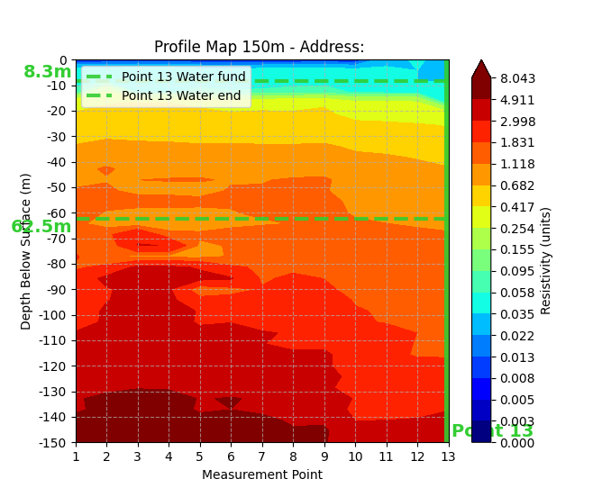
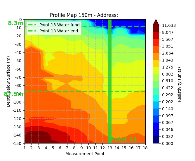
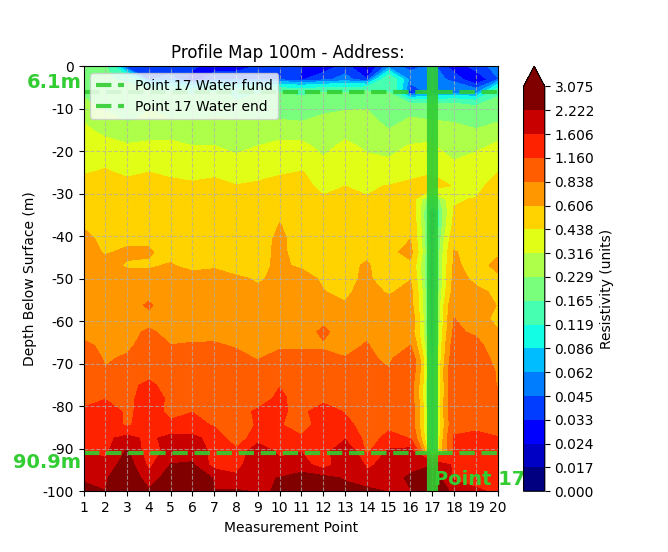
4. Tworzenie Mapy Rezystywności
Generowanie kolorowej mapy profilu gruntu na podstawie pomiarów rezystywności.
4. Creating a Resistivity Map
Generating a colored map of the soil profile based on resistivity measurements.
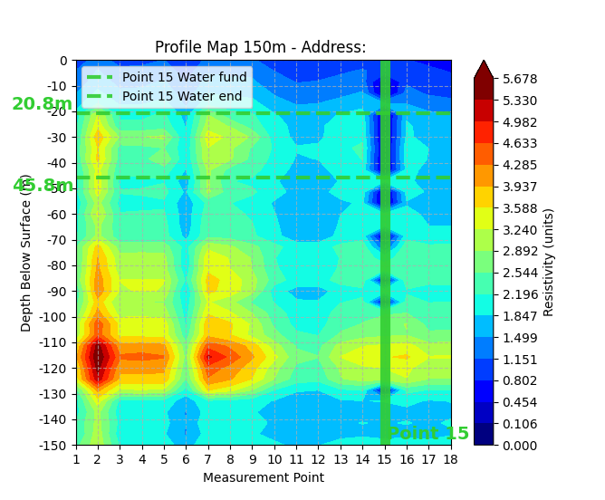
5. Analiza Rezystywności i Profilu
Podstawowy algorytm identyfikujący strefy niskiej rezystywności (potencjalna woda).
5. Resistivity and Profile Analysis
The basic algorithm identifying zones of low resistivity (potential water).
6. Wizualizacja Anomalii
Wyświetlanie obszarów odbiegających od normy, mogących wskazywać na wodonośce.
6. Anomaly Visualization
Displaying areas that deviate from the norm, potentially indicating aquifers.
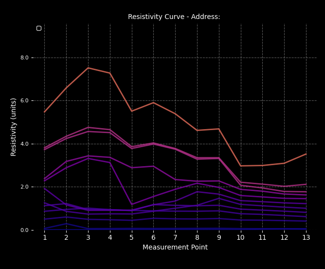
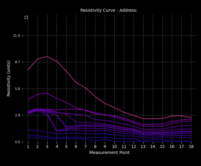
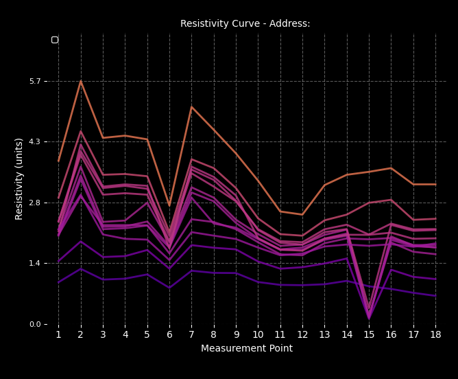
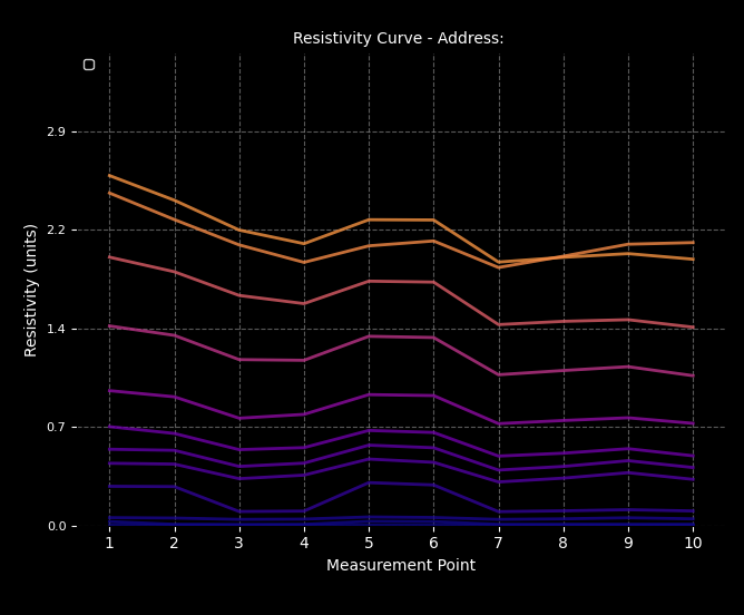
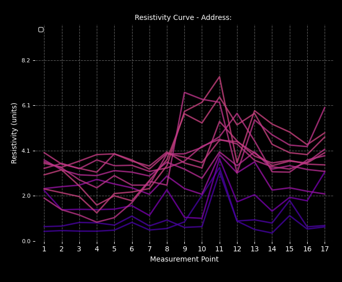
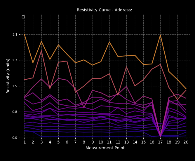
7. Wykres Przekrojowy Wód
Szczegółowy wykres ilustrujący przekrój warstw wodonośnych.
7. Cross-Sectional Water Chart
A detailed chart illustrating the cross-section of water-bearing layers.
8. Szacowanie Wydajności Warstwy
Oszacowanie potencjalnej wydajności (ilości) wody w zidentyfikowanych warstwach.
8. Layer Yield Estimation
Estimation of the potential yield (quantity) of water in the identified layers.
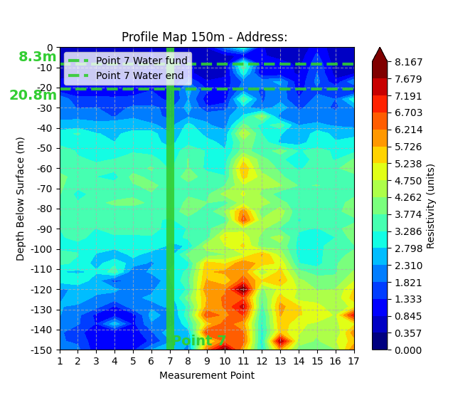
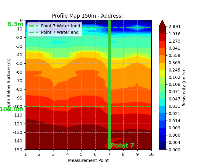
9. Precyzyjna Identyfikacja Wodonośców
Wskazanie dokładnej głębokości i zasięgu warstw wodonośnych, kluczowych dla odwiertu.
9. Precise Aquifer Identification
Indicating the exact depth and extent of water-bearing layers, crucial for drilling.
10. Generowanie Raportu Końcowego
Automatyczne tworzenie raportu z rekomendacjami w formacie PDF.
10. Final Report Generation
Automatic creation of a report with recommendations in PDF format.
11. Sugestie Miejsc Wiercenia
Wyświetlanie optymalnych punktów do wykonania odwiertu.
11. Suggested Drilling Locations
Displaying optimal points for bore execution.
12. Podgląd Danych 2D
Wizualizacja badanego terenu dla lepszego zrozumienia struktury geologicznej.
12. 2D Data Preview
Visualization of the surveyed area for a better understanding of the geological structure.
💰 Cennik i Zamówienie
- Wersja Demonstracyjna (V4) BEZPŁATNA
- (Ograniczona funkcjonalność i głębokość analizy do 50m). Pobierz plik demo (installdemoanalysis.zip)
- Wersja Pełna (V4) 1050 zł
- Licencja na jedno stanowisko robocze.
💰 Pricing and Ordering
- Demonstration Version (V4) FREE
- (Limited functionality and analysis depth to 50m). Download demo file (installdemoanalysis.zip)
- Full Version (V4) $300 USD
- License for one workstation.
Zamów Pełną Licencję Teraz!
Kliknij przycisk poniżej, aby złożyć zamówienie. Zostaniesz przekierowany do formularza e-mail z prośbą o dane niezbędne do wbudowania unikalnej licencji w Twoją kopię oprogramowania:
ZAMÓW PEŁNĄ WERSJĘOrder Full License Now!
Click the button below to place an order. You will be redirected to an email form requesting the data necessary to embed a unique license into your copy of the software:
ORDER FULL VERSION